Page 10: Moving to Whitehorse
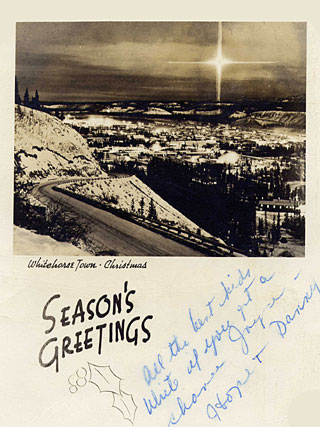
Whitehorse, Yukon Territory
New Northern Posting
This tour of duty, our last in the North, took place in 1959, seven
years after our short sojourn in Aklavik. We spent the three years
during 1953 to 1956 in Camp Shilo, Manitoba, where Dick was sergeant-major
of the Signals battery of the Royal Canadian School of Artillery.
In
1956 Dick was commissioned lieutenant and posted to the Signals squadron
attached to Headquarters, Prairie Command, and we moved to Winnipeg.
After three years of city life there, Dick's next posting was to the
Northwest Highway System headquarters in Whitehorse, Yukon Territory.
We prepared for another move - this time, a return to the North.
Not
quite knowing what to expect, we found Whitehorse to be an absolutely
different experience from either of our former northern postings.
During a reception in the Whitehorse Officers' Mess, a visiting VIP
asked me whether I was enjoying being a cheechako (the Yukon term
for a novice in the North). I replied that I found it a little difficult
to consider living in Whitehorse as actually living in the North.
It seemed more like life in the banana belt!
It
was not at all like living in either Fort Providence or Aklavik. The
northern border of the Yukon and its neighbours, the Northwest Territories
to the east and Alaska to the west, is the Arctic Ocean coastline.
But the Yukon's capital city, Whitehorse, is only a short distance
north of the British Columbia border to the south, on the 60th parallel.
Whitehorse's climate was not as severe as that of our previous northern
postings, neither was the town so isolated. The city was, in fact,
a very pleasant place in which to live!
Our time there proved to be quite as valuable an experience as living
in Aklavik or Fort Providence - its complete and utter difference
to our previous northern postings was one of its most interesting
features.
The
Northwest Highway System
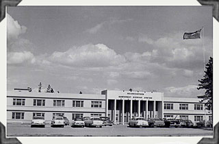
Headquarters Building, Northwest Highway System
Camp Takhini, Whitehorse (May 25, 1961)
The
completion of the Alaska Highway - from Dawson Creek, British Columbia,
to Whitehorse, Yukon Territory, and then to Anchorage, Alaska - resulted
in a remarkable transformation of the North.
From
Dawson Creek to Whitehorse, the "nine hundred and eighteen miles
of rough and dusty road" - as Al Oster, the "Yukon Balladeer,"
described the Highway in one of his most popular songs - made access
to the Yukon far easier than it had ever been before. From an isolated
town accessible only by air or by rail from Skagway, Alaska, on the
Pacific Coast, Whitehorse became a town easily reached by road.
In
the Gold Rush days of 1896 to 1904, when $100,000,000 in gold was
extracted from the Klondike creeks, reaching the Yukon required a
long and dangerous journey. The fortune hunters trekked in from the
coast, slogging over steep mountain passes and navigating frigid lakes
and turbulent rivers in hand-built boats or on rafts to reach the
Klondike gold fields.
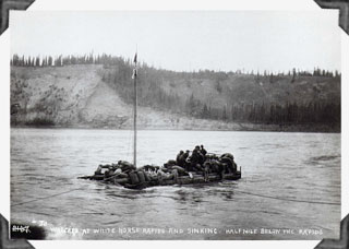
"Wrecked at Whitehorse Rapids and Sinking. Half Mile below the
Rapids" Photograph by E. A. Hegg, 1898.
Whitehorse,
named after the white-capped waves of the Whitehorse Rapids (now tamed
by a dam), lies on both sides of the Yukon River. When we arrived
in 1959, the town, as well as being accessible by road, was the proud
possessor of both an airport and a railway station. The railway, built
by the White Pass & Yukon Railroad in 1898-1900, ran from Whitehorse
along a precipitous and exciting route to Skagway, on the Alaska coast.
Long before the existence of the Highway, Skagway was the port of
entry for the many prospectors who travelled from all over the world
to stake their claims.
Getting
There
Our
journey to our new home was not by air, as it had been for our previous
postings. Nor did we try the ship-and-railway route. As we had been
posted to Northwest Highway System Headquarters, what could be more
appropriate than to travel there by road? We decided to combine our
move with summer holidays, see the country, and save money at the
same time, by making the journey a camping trip. So we loaded up our
new Morris Oxford station wagon with tent, provisions, and children,
and headed off on our voyage of Canadian discovery.
From
Winnipeg we drove west through the rolling terrain of southwest Manitoba,
and then into the Saskatchewan plains, where we could see as far as
our eyes could reach to the huge horizon all around us. We drove on
to Regina and then to the Cypress Hills, where we pitched our tent
for an overnight stay in that charming national park. Calgary was
our next stop, where the children equally enjoyed the live animals
in the zoo and, in the park on St. George's Island, huge concrete
replicas of the prehistoric animals that used to roam that country.
The
highway through the foothills of Alberta brought us at last to the
spectacular Rockies, the first mountains we had ever seen, let alone
driven through. Construction of the Trans-Canada Highway, then still
under way, made parts of our journey even more memorable than they
otherwise would have been. We had to squeeze past road-making machines
on narrow passes, staring through our car windows straight down the
impressive precipices. The children thought this was great fun - I
preferred not to look!
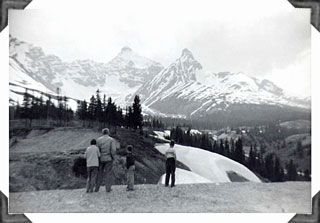
Sunwapta Pass (6,675 feet), Jasper National Park (July 1, 1959)
Banff
and Jasper national parks were wonderful to drive through. They were
perfect places in which to pitch a tent - the campgrounds were pleasant
and the surrounding forest and lakes were beautiful. Mountain sheep
and goats could be seen in the distance on the slopes of the mountains.
Closer to us, deer wandered along the verges of the road, hoping for
treats from passing tourists.
During our long drive, whenever the scenery lost the children's interest,
we resorted to our favourite car game, which we all enjoyed. The object
was to watch for car licence plates, collecting one from every province
in Canada and every state in the United States, and starting afresh
each day. At long last we managed to complete the grand total in Banff,
where the many tourists' cars included the really hard-to-find plates
from faraway places - even the NWT, Yukon, Newfoundland, and Hawaii!
It was the only time we managed to collect a complete set, and it
remained a never-to-be-forgotten family triumph.
We all enjoyed the novel experience of bathing in the hot springs.
In contrast to the cold mountain air, the water in the open-air pool
felt even more deliciously warm and relaxing. The same intriguing
coexistence of cold and heat fascinated us when we visited the glacier
ice fields in the middle of that hot summer.
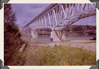
Peace River Bridge, Mile 35, Alaska Highway (July 9, 1961)
We
left Banff with some reluctance but, looking forward to new sights
on the road to the north, we drove on to Peace River. After crossing
the long bridge over the river, we carried on past the border between
Alberta and British Columbia to Dawson Creek, where the Alaska Highway
begins its long journey to the Yukon and Alaska.
[Next
Page]
Pages: [1]
[2] [3]
[4] [5]
[6] [7]
[8] [9]
[10] [11]
[12] [13] [14]
[15] [16]
Return to top of
page
Return to the Watts
Family page